Showing 31 items matching phillip island early roads
-
 Phillip Island and District Historical Society Inc.
Photographs, 1930's
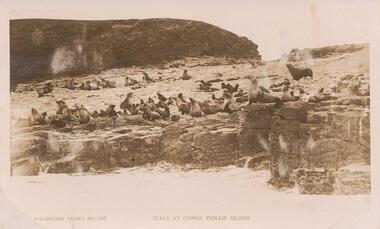
... phillip island early roads... phillip island early roads cowes pier phillip island cowes jetty ...13 photographs collected in the 1930's by Reg & Nell Price who lived at Sale, Gippsland at the time.Photograph 224-01. Sepia photograph of seals on Seal Rocks, Phillip Island Photograph 224-02. Black & White photograph of the dirt road to the Back Beach, Phillip Island. Photograph 224-03. Black & White photograph of the Cowes Pier/Jetty with the Cenotaph in the foreground. Photograph 224-04. Black & White photograph of Forrest Caves, Phillip Island. Photograph 224-05. Black & White photograph of Cape Woolamai Quarry. People and a small boat working. Photograph 224-06. Black & White photograph of the Cowes Pier taken through the trees on the foreshore. Photograph 224-07. Black & White photograph of Lover's Walk, Cowes with foot bridge in foreground. Photograph 224-08. Black & White photograph of rocky seascape at The Nobbies, Phillip Island. Photograph 224-09. Black & White photograph of Forrest Caves, Phillip Island. Photograph 224-10. Black & White photograph of Cowes Pier with the Ferries "Alvina" and "Genista". Many people also on the pier. Photograph 224-11. Black & White photograph of The Pinnacles, Cape Woolamai. Photograph 224-12. Black & White photograph of The Sentinel, Cape Woolamai. Photograph 224-13. Black & White photograph of the beach and pier at Cowes, Phillip Island.On the back of each photograph description of the photo.seal rocks phillip island, seals on seal rocks phillip island, phillip island early roads, cowes pier phillip island, cowes jetty, cowes cenotaph, phillip island, forrest caves, phillip island, cape woolamai quarries phillip island, lover's walk cowes, the nobbies phillip island, seascape, ferries, "alvina", ferry "genista" - cowes jetty, the pinnacles, the sentinel cape woolamai, reg & nell price, david price -
 Phillip Island and District Historical Society Inc.
Photograph, Unmade road in Cowes
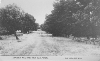
... Phillip Island early roads... Phillip Island early roads ...Part of a collection of 'Rose & Valentine' series of Post Cards. Copied by John Jansson 1984View of a beach road, Cowes. Unmade, grassy, tree lined street.Along Beach Road, Cowes, Phillip Island, Victoria. Real Photo Series M1256local history, photography, photographs, postcards, cowes, phillip island, black & white postcard copy, phillip island early roads -
 Phillip Island and District Historical Society Inc.
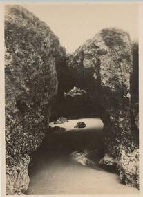
Photograph, Road to the Back Beach, 1925-1926
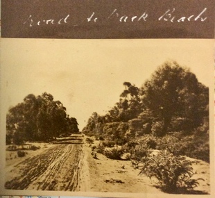
... Phillip Island early roads... Island early roads ...Sepia photograph of an rough, sandy, unmade road with trees and bushes along the side.Road to the Back Beachphotographs, phillip island early roads -
 Phillip Island and District Historical Society Inc.
Book, Articles on severance poll concerning split from Shire of Phillip Island and Woolamai 1925-1929, 1925-1929
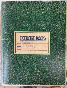
... Phillip Island early roads... Progress Association Phillip Island early roads Phillip Island ...Issue of severance of Phillip Island from the Shire of Phillip Island and Woolamai to become Shire of Phillip Island 1925-1929. This issue had strong opinions on both sides amongst Island residents and shows the political landscape of the times. This is a snapshot of life on Phillip Island in the 1920s. Book also contains notes, poem by D.H. Robb in his handwriting.HistoricalGreen exercise book with handwritten notes, articles from newspapers, pamphlets.Cover states D.H.Robb, Cowes. Lists of absentee ratepayers and householders, objectors,d.h.robb, severance of phillip island, local government, w.d.davie, akt sambell, women's progress association, phillip island early roads, phillip island valuations, local identities, reverend rath, tourism, phillip island 1920s, farming -
 Phillip Island and District Historical Society Inc.
Photograph, 1900's
This postcard is contained in an album presented to the then Governor of Victoria, The Earl of Stradbroke, by the fathers of soldiers & returned soldiers of Phillip Island, on 16/02/1923. The history of the album is noted on Reg. No 85-00Postcard of Beach Road, Cowes, showing stable on site of Continental Hotel, where horse and drags collected passengers to take to Summerland, early 1900's. Moreton Bay Fig planted by Von Mueller.The Rose Series P674. Beach Road Cowes, Phillip Island, Victorialocal history, photography, photographs, slides, film, beach road, cowes, phillip island, the esplanade, transport, moreton bay fig, sepia photograph, beach road cowes -
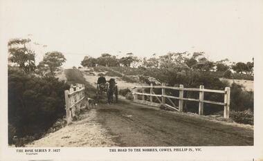 Phillip Island and District Historical Society Inc.
Sepia Photograph, 1920
This album was presented to the Earl of Stradbroke by Fathers of Soldiers on Phillip Island. The photo is of the early road to the Nobbies. Horse and trap crossing the old bridge with a dog in the foreground.Sepia photograph of the road to The Nobbies showing horse and trap crossing old wooden bridge with a dog in the foreground.Rose Series P 3427 The road to The Nobbies, Cowes, Phillip Is., Vicphillip island, the nobbies, wooden bridge, earl of stradbroke -
Phillip Island and District Historical Society Inc.
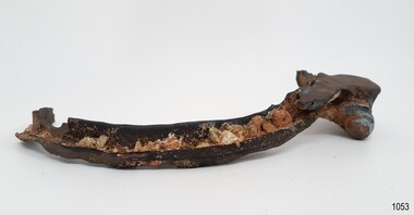
Grinding Mill, 1800 - 1900 (Estimated)
"A veritable powder puff of the stone ages and one of the most interesting relics of the Aborigines yet found on Phillip Island. A Grinding Mill for the soft red stone used for decorating the body. It was picked up by Mr H. R. Balfour of Hopetown Road, Toorak, in November 1904 and was kindly given to a member of the Phillip Island & Western Port Historical Society. Although used for the last ime more than 100 years earlier, some of the ground stone adheres to the surface that has been smoothed by much use." Taken from the label associated with this object. This label is a typed version of the original label.Grinding mill, oval shaped, stone is very regular and smooth with a textured surface. One side is worn flat and smooth and has traces of red ochre on it.local aboriginal history, aboriginal artifact, stone tool, aboriginal grinding mill -
Phillip Island and District Historical Society Inc.
Postcard
This Postcard came from the Estate of Keith McIlwraith on 20th July, 1983Road to the Back Beach, about 1.5 kilometres from Coweslocal history, documents, postcards, early postcards, postcard, beaches, phillip island -
Phillip Island and District Historical Society Inc.
Postcard
This Postcard came for the Estate of Keith McIlwraith on 20th July 1983.Mr. Robertson at the Shell House, Nobbies Road, Phillip Island.local history, documents, postcards, early postcards, postcard, shell house, phillip island -
Phillip Island and District Historical Society Inc.
Transparencies, 1990's
Slides in good condition but of a size not currently in use.8 Transparencies containing a view of Erehwon Point, a Kiln on French Island & a Kiln on Back Beach Road, Phillip Island.local history, photography, photographs, slides, film, buildings, historic, rural industry, agriculture, early slides, chicory kilns, phillip island -
Phillip Island and District Historical Society Inc.
Photograph, early 1900's
Eliza Coghlan was house keeper for James Duffus, who lived on property crn Rhyll/Newhaven Road and Phillip Island Tourist Road. Eliza Coghlan died in 1910 aged 113 years and is buried at the Phillip Island Cemetery (Monumental Section)Early settler - Eliza Coghlanlocal history, photography, photographs, slides, film, eliza coghlan, black & white photograph -
 Phillip Island and District Historical Society Inc.
Photograph, Bryant West, 1930
One of a collection of over 400 photographs in an album commenced in 1960 and presented to the Phillip Island & Westernport Historical Society by the Shire of Phillip IslandPhotograph looking down Cemetery Road,)unmade (now Coghlan Road) near Rhyll, lined with Gum Trees - early 1930's - car in centrelocal history, photography, photographs, cemetery road, rhyll, black & white photograph, roads, gum trees, cars, cemetery road to be renamed coghlan road, coghlan road phillip island, john jenner, bryant west -
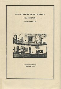 Surrey Hills Historical Society Collection
Book, Eustace Halley Coghill's Diaries Vol. VI 1939-1944 The War Years, 2000
Eustace Halley Coghill lived in Surrey Hills on the corner of Wandsworth Road and Chertsey Street. His home was moved to Phillip Island (photo in the collection). This is the sixth volume of his diaries transcribed and published by his daughter Elspeth Carey, who spoke to Surrey Hills Historical Society regarding her father's life. This volume covers Eustace Coghill working at the Supreme Court Library and lecturing at Melbourne University; his consideration regarding army enlistment and travels to country centres to check the court libraries.This is the sixth volume of the diaries. It continues with Eustace Coghill working at the Supreme Court Library and lecturing at Melbourne University. Also considering early entry to army in second World War. Travels also to country centres to check the court libraries.world war, 1914-1918, 1939-1945, social life and customs, eustace halley coghill (mr), elspeth coghill (miss), elspeth carey (mrs), diaries -
 Flagstaff Hill Maritime Museum and Village
Functional object - Porthole Frame, Russell & Co, 1888
This portion of the porthole frame was part of the fittings of the Antares. The Italian barque “Antares” was an iron three-masted sailing ship built in 1888 by Russell & Co of Port Glasgow. The ship was originally named the “Sutlej” but was renamed the “Antares” in 1907 when sold to the Semider Bros of Genoa, Italy, where it was registered. The vessel left Marseilles on the 18th of December 1913 with its master Captain Gazedo destined for Mullaly & Byrne of Melbourne with a cargo of roofing tiles but failed to arrive. The wreckage was found near the Bay of Islands, twenty-two miles east of Warrnambool, after a body had washed ashore. Some of the timbers washed up were charred by fire, and a small boat's stern board with the name "Sutlej" led to the identification of the wreck as Antares, which had been reported missing. According to later reports, the Antares wrecking was overshadowed by war news at the time. A young local boy had remarked that the Germans had arrived off the coast as he had seen them firing off shells and rockets, but his story was passed off as a joke. These rockets were most likely the distress signals from the stricken ship. The Italian barque, clipper, Antares was sometime later reported as overdue. The wreck of the ship was later found at the base of a cliff at the Bay of Islands near Warrnambool in November 1914; there were no survivors.The Antares is significant as it was a sail trader carrying international inbound cargo during the early part of the 20th century. It is part of the Great Ocean Road Historic Shipwreck Trail and as such is registered as a protected wreck in the Victorian Heritage Database VHS S34 .Porthole frame section, brass, large part corroded away. Hing is still visible on the end. The underside is shaped to allow the fitting of the glass. Recovered from the wreck of the Antares. Noneflagstaff hill, warrnambool, shipwrecked-coast, flagstaff-hill, flagstaff-hill-maritime-museum, maritime-museum, shipwreck-coast, flagstaff-hill-maritime-village, antares, tall ship, sailing ship, peterborough, phillip le couteur, peter mathieson, constable stainsbury, sutlej, antares rock., bay of islands, porthole, ship fitting, 1914 shipwreck, porthole frame -
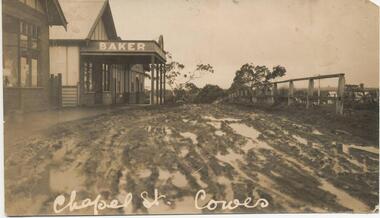 Phillip Island and District Historical Society Inc.
Photograph - Photograph, black + white
Donated by S Serpell of Serpell & Reid families, Sandringham.Small black + white photograph, with some damage to left quadrant and to both corners (right top and bottom). Image of a bakery, muddy road and early wooden fencing. Title noted at base in white handwriting.Chapel Street, Cowes.chapel street, cowes phillip island, phillip island bakery, s serpell -
 Phillip Island and District Historical Society Inc.
Photograph, 1950 approx
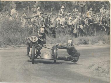
Donated by J W Gliddon with his comments on back of photograph. Taken when motorbike and car racing were run around the roads on Phillip Island. Racing first came to Phillip Island in 1927 in the form of a 200 mile road race for motorcycles on a circuit encompassing Cowes and Rhyll. In the next year, a shorter rectangular course, again on public roads, was used for the running of what became the first Australian Grand Prix. Eight successive Australian Grand Prix were run on this course before the race was moved elsewhere. Finally in 1935, racing was discontinued and Phillip Island lapsed into the tranquility and peacefulness of its quiet country and beach atmosphere.Black & White photograph of motorcycle riders on bike and sidecar. Crowd watching at the side of the road. See Historical Information for more detail re motorcycle racing on Phillip Island.On back: "This picture could become historically interesting as machines and methods change. It was taken about the year 1950. Perhaps earlier." motor cycle racing -
 Phillip Island and District Historical Society Inc.
Photograph, c 1930
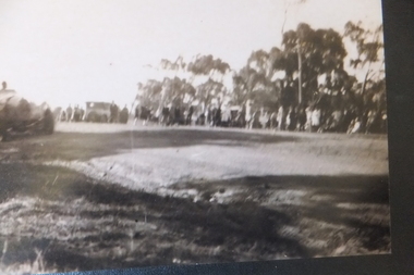
One of a collection of photographs purchased from Photo First, Thompson Avenue, Cowes, when it closed in June, 2014.Large Sepia photograph of the early 1930's? racing car on the road circuit with crowd watching.racing car, phillip island road racing circuit, photo first phillip island -
 Phillip Island and District Historical Society Inc.
Photograph Album, Kodak, Phillip Island Cemetery, c 1990
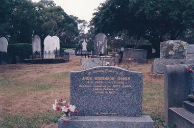
The Album was compiled by Nancy McHaffie late 1990's, with the assistance of Edith Jeffery's, with her book "Garden of Memories" and extensive knowledge of Phillip Island. The Cemetery lies back from the road and is surrounded by Manna Gums, rare Peppermint Gums, Blackwoods and other native trees. In all 25 acres of land were set aside as Crown Land in the land settlement of 1868. There are 6.2 acres of wetlands near the cemetery entrance.Jack Robinson Oswin: Many of the trees now flourishing in the cemetery grounds were planted by Jack Oswin and his wife Coral. Born in Mildura in 1909, his association with Phillip Island started when he attended the Cowes Primary School during the war years. He was foundation member of the Phillip Island Conservation Society and played a key role in the purchases of the area of land known as Conservation Hill. In the early 1980s he was awarded the British Empire Medal in recognition for his services to conservation. Jack died on December 4th 1990, aged 81 years.phillip island cemetery, jack robinson oswin, coral oswin, nancy mchaffie, edith jeffery -
 Phillip Island and District Historical Society Inc.
Photograph, Robert Miller
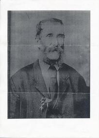
... settlers oh Phillip Island. See 402-03 Robert Miller Early Phillip ...Robert Miller selected block number 21 Watts Road, Ventnor in 1868 and he and his family came to be among the early settlers oh Phillip Island. See 402-03Large photocopy of portrait of Robert Miller - refer to Family History on 402-03robert miller, early phillip island settlers, watts road ventnor, lynette carr -
 Phillip Island and District Historical Society Inc.
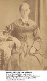
Photographs, Flora Miller & Catherine Walker, approx 1888
As noted under "Inscriptions)A4 photocopy of 2 portraits. One of Flora Miller and one of Catherine Walker (nee Kitty Miller) and familyFlora Miller (nee McInnis) wife of Robert Miller, early settler. In 1868 Robert Miller selected block number 21 Watts Road, Ventnor, next to Quoin Hill and the family lived there. Catherine Walker (nee Kitty Miller) photographed with three of her children around 1888. (The identity of the man and the youngest child in this photograph are unknown). Records show that Catherine's husband, James Walker, died in 1885. Her youngest child was her daughter, Flora, on left in photo.flora miller (nee mcinnis), catherine walker (nee kitty miller), robert miller, james walker, lynette carr -
 Phillip Island and District Historical Society Inc.
Photographs, Flora Miller & Catherine Walker (nee Miller), approx 1880's
The Millers & Walkers Phillip IslandTwo Photographs on backing sheet. 403-01: Flora Miller 403-02: Catherine Walker and family403-01: "Flora Miller (nee McInnis) Wife of Robert Miller, early settler. In 1868 Robert Miller selected block No. 21 Watts Road, Ventnor, next to Quoin Hill and the family lived there. 403-02: "Catherine Walker (nee Kitty Miller) Photographed with three of her children around 1888. (The identity of the man and the youngest child in this photograph are unknown. Records show that Catherine's husband, James Walker, died in 1885. Her youngest child was her daughter, Flora, on left in the photo).flora miller (nee mcinnis), catherine walker (nee kitty miller), james walker, robert miller, lynette carr -
 Phillip Island and District Historical Society Inc.
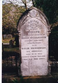
Photograph Album, Kodak, Phillip Island Cemetery, c 1990
The Album was compiled by Nancy McHaffie late 1990's, with the assistance of Edith Jeffery's, with her book "Garden of Memories" and extensive knowledge of Phillip Island. The Cemetery lies back from the road and is surrounded by Manna Gums, rare Peppermint Gums, Blackwoods and other native trees. In all 25 acres of land were set aside as Crown Land in the land settlement of 1868. There are 6.2 acres of wetlands near the cemetery entrance.466-23: Joseph Richardson came to Australia in 1837 from Liverpool, England. Sarah Arbuckle and her two sisters arrived in 1850. Sarah and Joseph were married when gold was discovered in Victoria. They went to the diggings and had some success. Joseph bought land on Phillip Island when it was open to freehold selection in 1868. The family moved to Phillip Island shortly afterwards, to a house they built on a hill west of Cowes. They called their home "Everton" after a Liverpool suburb. The house still stands in Church Street, known as "Tallawalla". 466-24: The McIlwraith family came from Melton, Victoria to Heath Hill, Rhyll in 1869. They played an important part in the early history of Phillip Island. James was a foundation member of the Trust, John and Alan played their part in the local scene. John was President and Alan Secretary of the Cemetery Trust for many years.phillip island cemetery, nancy mchaffie, edith jeffery -
 Phillip Island and District Historical Society Inc.
Photograph Album, Kodak, Phillip Island Cemetery, c 1990
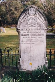
The Album was compiled by Nancy McHaffie late 1990's, with the assistance of Edith Jeffery's, with her book "Garden of Memories" and extensive knowledge of Phillip Island. The Cemetery lies back from the road and is surrounded by Manna Gums, rare Peppermint Gums, Blackwoods and other native trees. In all 25 acres of land were set aside as Crown Land in the land settlement of 1868. There are 6.2 acres of wetlands near the cemetery entrance.466-25: William and Alice Richardson: Alice Barnard married William Richardson at Hawthorn, April 1887. Alice's father Fredrick was a Model Maker employed at the Melbourne Museum. Alice died in childbirth having her third child, Joseph in 1892. Baby Joseph died in April 1893, eight months later at Rhyll. 466-26: The Forrest Family: The Forrest family were amongst our early settlers. The Forrest Caves are named after them. Matthew Forrest arrived by dray from Tarradale on 9th November 1869. He died in 1916 at the age of 75. His Grandson, Peter Forrest Sr. has recorded that Matthew was the first to plant Marum Grass on the Island to prevent erosion.phillip island cemetery, nancy mchaffie, edith jeffery -
 Phillip Island and District Historical Society Inc.
Photograph Album, Kodak, Phillip Island Cemetery, c 1990
The Album was compiled by Nancy McHaffie late 1990's, with the assistance of Edith Jeffery's, with her book "Garden of Memories" and extensive knowledge of Phillip Island. The Cemetery lies back from the road and is surrounded by Manna Gums, rare Peppermint Gums, Blackwoods and other native trees. In all 25 acres of land were set aside as Crown Land in the land settlement of 1868. There are 6.2 acres of wetlands near the cemetery entrance.466-34: Captain J. B. Lock. John Barnard Lock was associated with the trading vessels to operate from Phillip Island when the settlers had most of their goods brought from Melbourne. He died in 1908 and is laid to rest in the family grave. The grave is surrounded by metal railing and flowers. 466-35: David Charles Justice. David came to the Island in 1898. He was a blacksmith, coachbuilder, farrier, agricultural engineer, wheelmaker, shipbuilder and farmer. He purchased a farm from the Harbison Estate in 1911 in the Ventnor township. He assisted Mr Will Kennon in building a punt used to recover equipment from the wreck of the "Speke". "Dinny" as he was called, married Isabella Miller (an early settlers' family). He died in November 1943 aged 79. Isabella died in October 1936 aged 86. phillip island cemetery, nancy mchaffie, edith jeffery, captain john barnard lock, david charles justice, isabella justice -
 Phillip Island and District Historical Society Inc.
Photographs, Valentine's et al, Circa 1930
A collection of photographs/postcards donated by Dorothy Hurst. Her grandfather, Rev. Garthshore Stirling Home, was the vicar at the Anglican Church in Cowes - possibly in the early 1930's.235-01. Black & White photograph of Forrest Caves, Phillip Island. 235-02 & 03. Black & White photographs (identical) of two koalas up a tree. 235-04. Black & White photograph of the road to the Back Beach, Phillip Island. 235-05. Black & White photograph of a view of Cowes Pier taken through the trees on the foreshore. 235-06. Black & White photograph of Cape Woolamai Granite quarrie with people on the granite and in a boat. 235-07. Black & White photograph of waves breaking over the rock possibly near the Nobbies, Phillip Island. 235-08. Black & White photograph of The Vicarage at Cowes, Phillip Island - 1930's 235-09. Black & White photograph of a coastal scene at Phillip Island. 235-10. Black & White photograph of a coastal scene of the beach at Cowes. 235-11. Black & White photograph of waves breaking over the rocks near The Nobbies. 235-12. Black & White photograph of The Nobbies with Seal Rocks faintly in the distance. 235-13. Black & White photograph of The Nobbies with Seal Rocks in the background. 235-14. Black & White photograph of The Isle of Wight Hotel in the background. Cenotaph in foreground with a crowd of people, portable organ/piano plus music stands, people standing, children and others sitting on grass for Anzac Day or Remembrance Day. Possibly 1920s from fashions.235-01 Forrest Cave, Phillip Island 235-02 & 03 Native Bear (Koala) 235-04 The Road to the Back Beach, Cowes. 235-05 A Glimpse Thro' the Ti-Tree, Cowes. 235-06 The Quarries, Cape Wollomai, Phillip Island 235-07 The Beach near the Nobbies, Phillip Island. 235-10 The Beach at Cowes, Phillip Island. Valentine's Series M4847forrest caves, phillip island, wildlife - koalas, the nobbies phillip island, seal rocks phillip island, granite quarries, cape woolamai granite quarry, cowes cenotaph, phillip island, cowes pier phillip island, cowes beach phillip island, the isle of wight hotel cowes phillip island, cowes anglican church vicarage,phillip island, rev garthshore stirling home, dorothy hurst -
 Phillip Island and District Historical Society Inc.
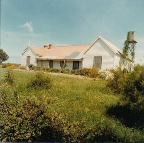
Photograph, 1978/9
"Heath Hill" was built by the McIlwraith brothers in 1872. They were one of the early settlers on the Island.Coloured photograph showing "Heath Hill" which was the house of the McIlwraith family on the Rhyll-Newhaven Road.local history, photographs, buildings - historical, housing, coloured photograph, john cook, phillip island, mcilwraith homestead -
 Phillip Island and District Historical Society Inc.
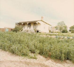
Photograph, 1978/79
Timber house with verandah and metal valence, built probably in the early 1900s.Coloured photograph of the home of Capt. Leonard McFee of the 'Genista', in Beach Road, Rhyll.local history, photographs, buildings - historical, coloured photograph, john cook, phillip island, l mcfee homestead -
 Phillip Island and District Historical Society Inc.
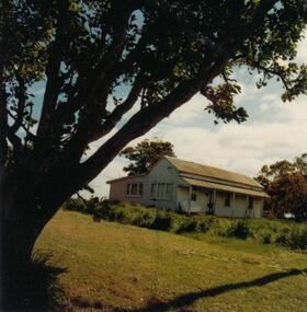
Photograph, 1978/79
Timber house with verandah built probably early 1900s.Coloured photograph of the home of Percy McFee, Newhaven-Rhyll Road.local history, photographs, buildings - historical, coloured photograph, john cook, phillip island, p mcfee homestead -
 Phillip Island and District Historical Society Inc.
Newspaper clippings, 05/10/1967
Collection of newspaper clippers in scrap book dated 1960 - 1973Newspaper article concerning the renaming of Cemetery Road as Coghlan Road in honour of Eliza Coghlan, an early pioneer; her grave to be given a facelift."113-y.o to be honored"local history, newspapers, cemetery road to be renamed coghlan road, cowes phillip island, miss eliza coghlan, jean jamieson -
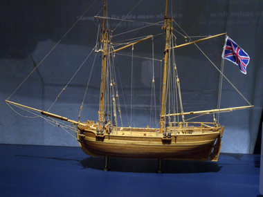 Flagstaff Hill Maritime Museum and Village
Craft - Ship Model, H.M.S. Lady Nelson, 1988
This model of the ship H.M.S. Lady Nelson was researched and built as the vessel Lady Nelson by David Lumsden, a professional ship model builder. His Majesty's Armed Survey Vessel Lady Nelson was commissioned in 1799 to survey the coast of Australia. This vessel was purpose-built before the British Admiralty requested plans for a Schooner for Port Jackson. At the time large parts of the Australian coast were unmapped and Britain had claimed only part of the continent. The British Government were concerned that, in the event of settlers of another European power becoming established in Australia, any future conflict in Europe would lead to a widening of the conflict into the southern hemisphere to the detriment of the trade that Britain sought to develop. Against this background, Lady Nelson was chosen to survey and establish sovereignty over strategic parts of the continent. Lady Nelson left Portsmouth on 18 March 1800 and arrived at Sydney on 16th December 1800 after having been the first vessel to reach the east coast of Australia via the Bass Strait. Before that date, all vessels had sailed around the southern tip of Tasmania to reach their destination. Lady Nelson's survey work commenced shortly after she arrived in Sydney, initially in the Bass Strait area. She was involved in the discovery of Port Phillip, on the coast of Victoria, in establishing settlements on the River Derwent and at Port Dalrymple in Tasmania. She also successfully chartered much of the Victorian coastline and was heavily involved with the exploration of the Queensland coast with Matthew Flinders; investigated the Hunter River; made numerous visits to New Zealand and Norfolk Island and was involved in the founding of numerous settlements. In comparison to most colonial vessels, the Lady Nelson was technically unique she was fitted with sliding keels, or centreboards, and water-tight trunks reaching to the deck. Captain Schank invented these sliding keels that, when raised, reduced her draught to less than six feet. Her life as an exploration vessel ended while accompanying HMS 'Tamar' to Melville Island in 1825, the 'Lady Nelson' was captured and later abandoned by pirates off the island of Babar (Indonesia). This brought the vessel's 25 years of coastal exploration and navigation to a close.The Lady Nelson made was the first British ship to survey of the southern or south-western coast of Australia and traverse the Bass Strait. The vessel holds a special place in Australia's history of exploration as the first to explore and establish settlements in the then-new British colony of Van Diemans Land. The model gives an insight into what life must have been like onboard sailing vessels of the time and Australia's early history of establishment and exploration. This model acts as an important legacy of the full-scale ship which no longer survives. Ship model of the 60 ton British brig HMS Lady Nelson. Timber model of a two-masted brig with rigging but no sails, displaying the British Union Jack flag. The ship is in a glass exhibition display case on metal stand. HMS Lady Nelsonflagstaff hill, warrnambool, shipwrecked coast, flagstaff hill maritime museum, maritime museum, shipwreck coast, flagstaff hill maritime village, great ocean road, by captain john schanck, sliding keels or centreboards, lady nelson, british brig hms lady nelson, david lumsden ship model builder, lieutennant james grant, bass strait discovery, surveying king island and port phillip bay, philip gidley king